")
This blog entry focuses on the challenges in the choice of model input parameters, terrain data and modelling software in flood modelling of rivers, especially those in Nepal. Her post tries to acknowledge the limitations of flood inundation maps generated through these models.
Flood mapping highlights the major spatial information on flood hazard, which forms robust information on costs and benefits of flood preparedness, decision-making for disaster risk reduction, recovery and overall planning for integrated catchment development [1]. Exact prediction of the future flood in terms of flood onset, duration, depth of flooding, the extent of inundation and attenuation of peak flood is difficult especially in the context of Nepali rivers with limited resources and incomplete data availability. Flood mapping is even more complicated for the Karnali river and floodplain due to the channel’s highly mobile and dynamic nature [2]. Fortunately, it is still possible to generate valuable and cost-effective flood maps with modest computer power and field validation of data. Such an attempt has been made by the University of Edinburgh in collaboration with Practical Action Consulting, Nepal to understand Karnali floodplain hazard and the role of sediment dynamics through flood modelling.
A flood inundation model is a simplified representation of physical phenomena. As models are based on a simplification of complex processes, the results require interpretation. The quality of modelling output in the form of flood maps is dependent on the input data, and on the efficiency of the model to represent the physical processes accurately; thus, the best model being the one that represents the environmental phenomena with least parameter complexity and also least model complexity [3]. The complexity, data requirements, expenses and modelling time increases when stepped up from 1-D to 3-D models at the cost of attaining physical realism. Adding more causes and parameters does not necessarily increase model performance but by adding each new cause/parameter into a model, a new uncertainty associated with that cause/parameter is introduced. Thus, the quality and accuracy of model outputs depend largely on the input data (digital elevation model, hydrology data, sediment data) and parameters that are introduced in the model (channel and roughness coefficient) and the flood routeing method applied.
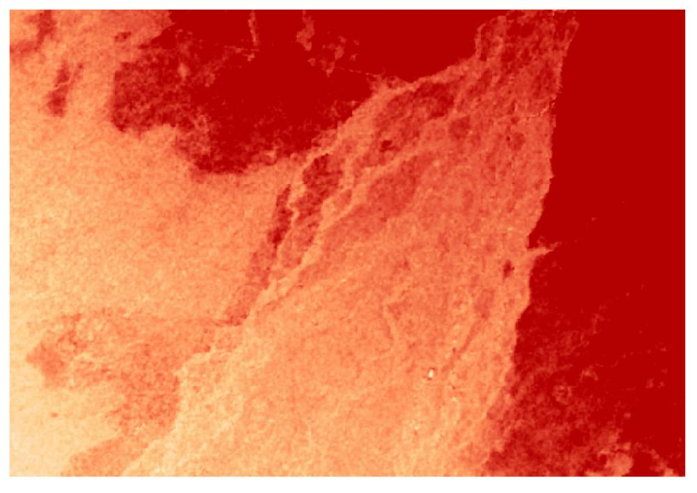
Open-source Digital Elevation Models (DEMs) such as SRTM and ASTER DEMs have been commonly used for flood modelling in Nepal [5]. However, the spatial resolution and the vertical accuracy of such DEMs govern the way in which water is routed across the landscape, determining the extent and depth of flood waters and thus, raising questions on the reliability of such flood maps. Where floodplain topographic features are smaller in magnitude than the vertical error of the DEM, this can be problematic. Finer resolution topography allows smaller floodplain features to be explicitly represented within the DEM. The major challenge with the 30m resolution SRTM dataset is its large vertical error up to 16m. On the other hand, the use of TanDEM-X in this project has helped obtain a spatial resolution of 10m and a vertical accuracy of 1m, significantly improving the ground representation compared to other data sets. However, one major challenge is that TanDEM-X and SRTM data represent the elevation of the reflecting surface that the waves encounter at first. Hence, the data are not always representative of the ground surface but could be representing the tree tops, buildings or any other reflecting medium and need corrections accordingly [6]. This can create artifical highs or lows in the DEM, which may modify the modelled flood pathway.
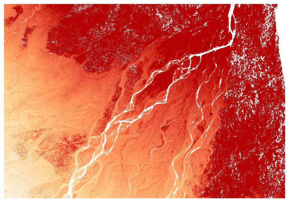
A natural channel flow is governed by physical processes occurring in all three dimensions [7, 8]. The complexity in 3-D models arises from solving Navier-Stokes equation, which governs the flow in three dimensions. 2-D models come with ease in defining parameters in the model along with fast computational capability. In Nepal, HEC-RAS [9, 10] has been popularly used for one-dimensional and two-dimensional hydraulic routeing of the flood [11, 12] without taking into account the sediment characteristics of the flood. The major challenge with HEC-RAS is that the models tend to be unstable in highly dynamic streams [11,13]. The use of 2-D models in Delft-3D helps overcome this instability issues and improves the approximation of the flow. On the other hand, the sediment flow characteristics being the crucial factor in understanding the dynamics of the river, different scenarios of sediment condition have been considered by changing the bed level of the river. Also, for the first time, an attempt has been made to understand the impact to downstream flow and channel switching due to sediment aggradation at the bifurcation point in Karnali.
Better approximation in flood modelling comes from the choice of other input parameters such as the bed and floodplain roughness coefficient [7] and channel cross sections. In this research, the use of Acoustic Doppler Current Profiler (ADCP) in Nepali river has allowed the channel cross sections and water discharge to be represented and model results validated with good accuracy. Manning’s coefficient for the channel roughness was updated based on new sediment grain size measurements with two values for the gravel and sand bedded portions of the channel, and one for the floodplain. Subjective judgement on the choice of parameters for minimising uncertainties will remain a challenge in Karnali flood modelling. Amidst the modelling challenges, other model assumptions and the lack of field data for validation of model (e.g. actual flood inundation depths and extent), this new approach of using Delft-3D model for the first order risk assessment with application of the best available DEM data and addition of sediment characteristic has put light on new aspects of risks, which remain unidentified through existing flood modelling methods for this region.
References
[1] Smith, K., 2013. Environmental hazards: assessing risk and reducing disaster. Routledge.
[2] Department of Irrigation, 2011. Environmental Management Plan Final Report: Modernization of Rani Jamara Kulariya Irrigation Scheme Phase I
[3] Wainwright, J. and Mulligan, M. eds., 2005. Environmental modelling: finding simplicity in complexity. John Wiley & Sons.
[4] Saksena, S. & Merwade, V., 2015. Incorporating the effect of DEM resolution and accuracy for improved flood inundation mapping. Journal of Hydrology, 530, pp.180–194.
[5] Burrough, P. A. and McDonnell, R. A., 1998, Principles of geographic information systems, New York: Oxford University Press
[6] Gallant, J.C., Dowling, T.I., Read, A.M., Wilson, N., Tickle, P., Inskeep, C., 2011,1 second SRTM Derived Digital Elevation Models User Guide. Geoscience Australia
[7] Chow, VT. (1959). Open-channel hydraulics, McGraw-Hill Book Co., New York
Comments