")
Karnali, Chisapani station is the sole hydrological station representing vast downstream region of Bardiya and Kailali district, even beyond the Nepal-India border. Considering the complex river dynamics of Karnali and its breaded form several kilometres downstream, sometimes flood early warnings based on water level at Chisapani does not correlate with the flood levels for the downstream communities.
Also there have been some instances of system failure of Chisapani station in past. Advent of low cost sensors ($300-$500) and most importantly the concept of citizen science for scientific data cogeneration has now opened up new perspectives of flood risk management at Karnali. Making the technology cheap, not only makes them more accessible and complimentary to existing monitoring station but also a unique opportunity to deploy them in large scale at various locations of upstream and downstream of the river.
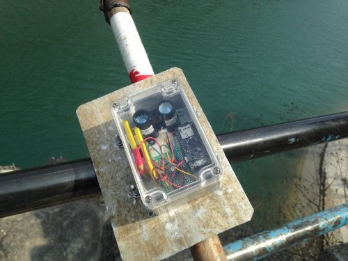
Under the Ecosystem Services for Poverty Alleviation (ESPA) Program, Practical Action has been supporting Imperial College London to test the robustness of low cost water level sensors in Karnali River since May 2016. Acoustic sensors previously installed at Chisapani Station upstream and Sattighat Bridge downstream were , continuously recording data in data-logging system, however low range of measurement have made them unsuitable for Karnali River.
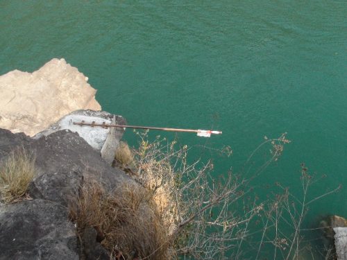
Therefore, Lidar sensors (light based) with a measurement range up to 30 m have been recently installed in those locations for further testing and suitability in the local context. As a part of citizen science approach, several local engagements and demonstration of the sensors were also carried out at upstream and downstream communities including one district level stakeholder consultation at Gularia, Bardiya to discuss on the local perception on this cheap technology. Communities and stakeholders are very keen to look at its applicability and complementarity in the ongoing flood reduction program of the region.

Further, the next step will be to make the system real-time and user-friendly such that it could be then linked with the existing community based flood early warning system. In Collaboration and partnership from the stakeholders and the communities, this cheap technology could be a major step forward in improving local resilience and decision making for flood risks in the Karnali Basin.
This project is funded by the Ecosystem Services for Poverty Alleviation (ESPA) programme and uses a citizen science approach to support flood risk management in the Karnali River basin and plans to work with key partners to extend the use of this approach across Nepal.
Know more about the Enhancing Community Based Early Warning Systems in Nepal with Flood Forecasting Using Local and Global Models
Comments