")
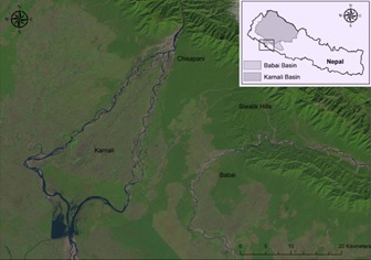
The Karnali is a trans-boundary river that originates from the Himalayas and flows along the steep and hilly terrain of West Nepal. The Karnali drains into the Terai plains from a narrow gorge at Chisapani where the river splits into the Geruwa and Karnali rivers, creating an inland delta before converging as the Ghagra in India (Zurich 2015).
The river carries snow fed flows and has significant discharge even during the dry seasons. Based upon historical discharge records, 80% of the total flow occurs during the monsoon season with maximum flow events mostly occurring during the months of June through September (Dixit, 2009).
The geomorphological origins of the Karnali bifurcation along with river shifting is not well understood, which is probably dictated by tectonics and attributed to the process of mountain building in the Himalayas (Sinha et al, 2014). Despite being one of the largest rivers of Nepal, there exists dearth of research on river morphology of the Karnali mega-fan (Zurich, 2015), and even less is known regarding the sediment dynamics and its impact on flooding at a basin scale. However, what is known is that the Karnali River floods the Terai plains every few years, and the frequency has increased in the past decade with major floods occurring in 2008, 2009, 2013 and 2014.
Understanding the catchment response for rivers in Nepal is highly complex owing to the dynamic geomorphology upstream coupled with topographic and geological constraints (Nepal et al. 2014). Moreover, it is challenging to comprehend the catchment response during high intensity and short duration precipitation events that trigger flash floods downstream (Shrestha et al, 2008). Floods are also dependent upon river morpho-dynamics and local slope conditions and generally follow non-linear pathways (Sinha et al, 2014).
It is critical to understand non-linear pathways to flooding in large river basins such as Karnali, where myriad of engineering structures such irrigation canals and hydropower plants are currently being planned to divert water flows. With the changing climate, magnitude and frequency of floods are expected to increase in the near future (NCVST, 2009), altering the dynamics and carrying capacity of the rivers that would most likely impact the future flood conditions, which cannot be discounted for the Karnali River.
References:
- Dixit, A. (2009). Kosi embankment breach in Nepal: Need for a paradigm shift in responding to floods. Economic and Political Weekly, 70-78.
- Gautam, D. K., & Dulal, K. (2013). Determination of threshold runoff for flood early warning in Nepalese Rivers. IDRiM Journal, 3(1), 126-136.
- Nepal, S., Flügel, W. A., & Shrestha, A. B. (2014). Upstream-downstream linkages of hydrological processes in the Himalayan region. Ecological Processes, 3(1), 1-16
- NCVST. (2009). Vulnerability through the Eyes of Vulnerable: Climate Change Induced Uncertainties and Nepal’s Development Predicaments. Kathmandu: Institute of Social and Environmental Transition-Nepal (ISET-N), Nepal Climate Vulnerability Study Team (NCVST)
- Shrestha, A. B., Shah, S. H., & Karim, R. (2008). Resource manual on flash flood risk management. Internat. Centre for Integrated Mountain Development, ICIMOD.http://lib.icimod.org/record/7891
- Sinha, R.; Kale, V.S.;Chakraborty, T. (2014), Tropical rivers of south and southeast Asia: Landscape evolution, morpho-dynamics and hazards, Geomorphology 227, 1–4
- Zurich Insurance (2015). Risk Nexus:Urgent case for recovery: what we can learn from the August 2014 Karnali River floods in Nepal.
Comments